In the rapidly evolving landscape of modern technology, few innovations have captured the imagination and transformed industries quite like LIDAR. This groundbreaking sensing technology is reshaping our understanding of the world around us, from the cars we drive to the ancient civilizations we uncover. But what exactly is LIDAR, and how does it work? Let's embark on an enlightening journey to explore the depths of this fascinating technology.
Unraveling the Essence of LIDAR
LIDAR, an acronym for Light Detection and Ranging, stands at the forefront of remote sensing technologies. At its core, LIDAR operates on a principle similar to echolocation used by bats, but with a crucial difference – it uses light instead of sound. This sophisticated system employs laser pulses to measure distances and create intricate 3D maps of the environment with remarkable precision.
The fundamental process of LIDAR is elegantly simple yet profoundly effective. A laser emitter releases a pulse of light, typically in the near-infrared spectrum, which travels outward until it encounters an object. Upon contact, the light reflects back to a sensor in the LIDAR system. By measuring the time taken for the light to return, the system calculates the distance to the object with extraordinary accuracy. This process is repeated millions of times per second, scanning in all directions to build a comprehensive 3D picture of the surroundings.
The Intricate Architecture of LIDAR Systems
To truly appreciate the complexity and capability of LIDAR, it's essential to understand its key components. At the heart of every LIDAR system lies the laser emitter, a precision instrument that generates rapid pulses of laser light. These pulses are then directed across a wide area by a sophisticated scanner and optics system, often utilizing rotating mirrors to achieve a broad field of view.
The returning light is captured by a highly sensitive photodetector, capable of registering even the faintest reflections. For mobile LIDAR systems, such as those mounted on vehicles or aircraft, a GPS receiver works in tandem with an Inertial Measurement Unit (IMU) to precisely locate each measurement in three-dimensional space. This geospatial data is crucial for creating accurate maps and models.
Finally, a powerful data storage and processing unit collects and interprets the vast amounts of information generated by the system. Modern LIDAR setups can collect over a million data points per second, requiring significant computational resources to manage and analyze this data deluge.
The Art of 3D Mapping with LIDAR
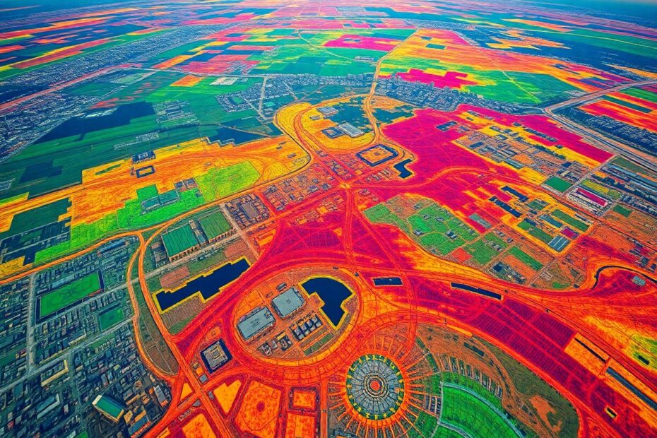
The process by which LIDAR creates 3D maps is a testament to the power of modern computing and sensor technology. As the LIDAR system scans its environment, each reflected laser pulse becomes a point in 3D space. The collection of these points forms what's known as a "point cloud" – a three-dimensional representation of the scanned area.
The density of this point cloud can be staggering. High-end LIDAR systems can generate over 100 points per square meter, providing an incredibly detailed digital replica of the physical world. Specialized software then processes this point cloud, identifying patterns and structures to create a coherent 3D model.
This ability to rapidly and accurately capture three-dimensional data sets LIDAR apart from traditional mapping techniques. Where conventional surveys might take weeks or months to complete, LIDAR can map large areas in a matter of hours, with centimeter-level accuracy.
LIDAR in Action: Diverse Applications Across Industries
The versatility of LIDAR technology has led to its adoption across a wide spectrum of fields, each harnessing its unique capabilities to solve complex problems.
In the realm of autonomous vehicles, LIDAR serves as the eyes of the car, creating real-time 3D maps of the surrounding environment. This allows self-driving systems to detect obstacles, recognize road features, and navigate safely through complex urban landscapes. Companies like Waymo and Velodyne are at the forefront of developing automotive LIDAR systems, pushing the boundaries of what's possible in autonomous navigation.
The field of archaeology has been revolutionized by LIDAR technology. Airborne LIDAR systems have the remarkable ability to penetrate dense vegetation, revealing hidden structures and landforms beneath. This capability led to the discovery of previously unknown Mayan cities in the jungles of Central America, rewriting our understanding of this ancient civilization. The National Center for Airborne Laser Mapping (NCALM) has been instrumental in these archaeological breakthroughs, using LIDAR to uncover lost cities and ancient road networks across the globe.
In forestry and environmental sciences, LIDAR provides unprecedented insights into forest structures and ecosystems. By accurately measuring tree heights, canopy densities, and understory characteristics, LIDAR helps in estimating biomass, monitoring deforestation, and managing forest resources more effectively. The U.S. Forest Service, for instance, uses LIDAR extensively in its Forest Inventory and Analysis program, providing crucial data for sustainable forest management.
Urban planners and civil engineers leverage LIDAR to create detailed 3D models of cities, aiding in infrastructure planning and development. These models help in everything from flood risk assessment to the optimal placement of 5G networks. Cities like New York and Singapore have created comprehensive LIDAR-based digital twins of their urban environments, facilitating smarter, more efficient city management.
In the field of geology and seismology, LIDAR's ability to detect minute changes in land elevation proves invaluable. By repeatedly scanning the same area over time, geologists can identify subtle ground movements that might indicate impending earthquakes or volcanic activity. The U.S. Geological Survey employs LIDAR extensively in its earthquake hazard program, providing critical data for risk assessment and emergency preparedness.
The Technological Horizon: Future Prospects of LIDAR
As LIDAR technology continues to evolve, we stand on the brink of even more exciting developments. One of the most significant trends is the miniaturization and cost reduction of LIDAR sensors. Companies like Velodyne and Ouster are developing solid-state LIDAR systems that are smaller, more robust, and significantly cheaper than traditional mechanical LIDAR units. This advancement promises to make LIDAR technology more accessible for a wider range of applications, from personal robots to augmented reality devices.
Improvements in LIDAR resolution and range are also on the horizon. Next-generation systems promise to offer even more detailed scans with longer range capabilities. This could be particularly transformative for autonomous vehicles, enabling them to detect and respond to potential hazards at greater distances.
The integration of LIDAR with other sensing technologies and artificial intelligence is another frontier of innovation. By combining LIDAR data with information from cameras, radar, and other sensors, we can create more comprehensive and reliable environmental understanding systems. AI algorithms can then interpret this rich data set, enabling more sophisticated decision-making in applications ranging from autonomous vehicles to smart city management.
Despite its immense potential, LIDAR technology faces several challenges that researchers and engineers are actively working to overcome. One of the primary hurdles has been the cost of high-quality LIDAR systems. However, recent advancements in solid-state LIDAR and mass production techniques are rapidly bringing costs down, making the technology more accessible.
Another significant challenge lies in processing the massive amounts of data generated by LIDAR systems. A single LIDAR scan can produce gigabytes of point cloud data, requiring substantial computational power to process and analyze. To address this, companies like Nvidia are developing specialized hardware and software solutions designed to handle LIDAR data more efficiently.
Environmental factors such as rain, snow, and fog can interfere with LIDAR measurements, potentially compromising the reliability of the system in adverse weather conditions. Research is ongoing to develop more robust LIDAR systems that can operate effectively in a wider range of environmental conditions. Some approaches involve using multiple wavelengths of light or combining LIDAR with radar for improved all-weather performance.
The challenge of accurately detecting very reflective or very dark objects remains an area of active research. Advanced signal processing techniques and multi-spectral LIDAR systems are being developed to improve performance across a wider range of surface types and lighting conditions.
LIDAR's Transformative Impact: Reshaping Our World
The impact of LIDAR technology extends far beyond its technical capabilities, fundamentally changing how we interact with and understand our world. In the realm of transportation, LIDAR-equipped autonomous vehicles promise to revolutionize road safety. The National Highway Traffic Safety Administration estimates that self-driving cars could reduce traffic fatalities by up to 94%, potentially saving tens of thousands of lives each year in the United States alone.
Environmental monitoring and conservation efforts have been dramatically enhanced by LIDAR technology. Researchers can now track deforestation, coastal erosion, and other environmental changes with unprecedented accuracy. For instance, the Global Ecosystem Dynamics Investigation (GEDI) LIDAR system on the International Space Station is mapping the world's forests in 3D, providing crucial data for understanding global carbon cycles and biodiversity.
In the field of cultural heritage preservation, LIDAR is unveiling hidden historical sites and helping us understand our past in new ways. The discovery of previously unknown archaeological sites, like the ancient city of Mahendraparvata in Cambodia, demonstrates LIDAR's power to reshape our understanding of human history.
The concept of smart cities is being realized through LIDAR-generated 3D maps, enabling more efficient urban planning and management. Cities can optimize everything from traffic flow to emergency response using these detailed digital models. For example, Singapore's "Virtual Singapore" project uses LIDAR data to create a comprehensive digital twin of the entire city-state, facilitating better decision-making in urban planning and management.
Conclusion: Illuminating the Path Forward
As we look to the future, LIDAR stands as a shining example of how cutting-edge technology can illuminate our world in ways we never thought possible. From helping autonomous vehicles navigate city streets to uncovering lost civilizations and mapping the changing face of our planet, LIDAR is truly shedding new light on the world around us.
The ongoing refinement and miniaturization of LIDAR systems promise to make this technology an even more integral part of our daily lives. As we continue to push the boundaries of what's possible with LIDAR, we can anticipate groundbreaking applications in fields we've yet to imagine.
LIDAR represents more than just a way to measure distances; it's a powerful tool for understanding and interacting with our three-dimensional world. It embodies the transformative potential of technology to enhance our understanding, improve our safety, and help us make more informed decisions about our environment.
As this technology continues to evolve, one thing is clear: the future of LIDAR looks exceptionally bright. It stands poised to play a pivotal role in shaping our future, from the cars we drive to the cities we live in and the way we understand our planet and its history. In the grand tapestry of technological innovation, LIDAR shines as a brilliant thread, weaving together the physical and digital worlds in ways that continue to astound and inspire.